Apache Trail
Local Flavor · Maricopa County ·
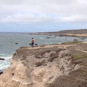
Scenic desert drive past lakes, ghost towns, and mountains


Information
Arizona Get directions
Scenic desert drive past lakes, ghost towns, and mountains
Arizona Get directions
"Driving the Apache Trail is one of the most rewarding day trips from Phoenix. It was originally made by the Apache tribe to move through the rugged wilderness of the Superstition Mountains. Later used by stagecoaches, this road remains the best and most scenic way to get through the mountains. Though roughly half of the 40-mile loop is dirt, driving it is not only a great adventure but the perfect way to experience the history and wilderness of the area near Phoenix.The first stop on the trail, Goldfield ghost town, an old mining town set up during the gold rush, offers a glimpse into the history of the Superstition Mountains and its surroundings. Across the street, the Lost Dutchman State Park, crisscrossed by trails, gives hikers and bikers of all abilities an opportunity to experience the Superstition mountain wilderness.Driving on the Apache trail through a narrow scenic road with steep canyon walls, you eventually reach Canyon Lake, a good place to take a short hike. Come lunchtime, Tortilla Flat, a settlement with six residents, offers authentic Southwest fare and a glimpse into an old-fashioned curio shop. Past this tiny town, the road turns into dirt and continues on the shore of the long and narrow Apache Lake, until it reaches Roosevelt Dam, crossing some of the most lovely scenery.Tonto National Monument, the next place worth a longer visit, features Salado-style cliff dwellings. The dirt road and the Apache Trail ends at Roosevelt Lake. However, there is no need to turn around. Instead, continue on towards the Boyce Thompson Arboretum, the state’s oldest and largest botanical garden, a great destination for an afternoon stop before heading back to Apache Junction and Phoenix." - MATADOR_NETWORK

Evelyn D.

Kris L.

Fred T.

Yuko H.
James L.

Laura G.

Amy M.

Philip W.

Elvi T.
Doris W.

Jamie B.

Sherly W.

Daniel C.

Lindsey D.

Christine A.

Joe R.

Robyn N.

Mark S.

Jon M.

Carolyn G.

Terry T.

Nicole L.

Marco N.

Valerir M.

Heather C.

Krsna V.

Jessica S.

Bill G.

Chris H.

Nick L.

Lori M.

Joyce H.

Julia E.

T J.

Heidi C.

Dan O.

Maynard C.

Stephanie J.
Mary F.

Phil T.

Jennifer S.
Larry G.
Jim K.
Lisa T.

Anna R.

Marissa P.

Saba B.

Nicole F.

Stacy M.
