Esther Y.
Yelp
There was no listing for Maggie's Peak so this will have to do since this is the trailhead for the hike. It was really confusing b/c there are no signs that say this is the hike for Maggie's Peak...all it says is Desolation Wilderness. Permit required, but there's a self-serve kiosk at the trailhead - just fill out a card, tear off the bottom and drop it in the box, and attach the rest to your backpack.
We started the hike up and found it to be quite steep. I'm not an experienced hiker, but I probably would've called this strenuous instead of moderate, which is the official rating. The description I read also said it was steep for the first mile, then flattens out. Nope. It was steep for the entire 1.5 miles up. The trail isn't super well-marked either (which the description was also misleading about...it said the trail was easy to navigate). There were several forks and we went off course several times and came to a dead end, having to backtrack and take the other fork to get back on track.
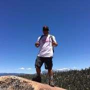
The trail passes through some scenic locations: about 0.5 miles in, you get a nice view of Emerald Bay. About 0.75 miles in, you get really close to Granite Lake, which is beautiful. 1.4 miles in, you get a beautiful view of the valley. 1.5 miles in is Maggie's Peak South (the last 0.1 miles is very difficult - super steep and no clear trail...just keep heading straight up and you'll be fine...leave rock markers along the way so you can find the trail again when you come back down). Absolutely gorgeous, stunning, unobstructed, sweeping panoramic views of the entire South Lake Tahoe and 3 other small lakes (Granite Lake is the only one I know). It's a bit scary up there as it requires some maneuvering on top of rocks, and the fall down would be extremely steep and scary... o_O
I think it took us about 1.5 hours to get to the top, maybe a little longer. It only took about 30-40 minutes to get all the way back down to the trailhead...we were practically running as the sun was starting to set. Fortunately all downhill.
SUMMARY:
- 3.0 mile roundtrip
- steep, moderate-to-strenuous
- trail often unmarked
- bring lots of water
- park at Inspiration Point, walk in to the campground to the trailhead
definitely have someone with a smartphone and the EveryTrail app or some other hiking app to make sure you're on the right course
- take the Desolation Wilderness route
I wish I had read these in full detail, so I'm passing along this advice to you now!
http://www.tahoeadventuresports.com/hikeindex/west/granite.htm
http://www.everytrail.com/guide/maggies-peaks
This site says you can also take the Eagle Falls trail back that drops you off on the road not too far from Bayview Trailhead...but takes a little longer than just backtracking. Great if you hate going back the same way you came. ;) http://www.summitpost.org/maggies-peaks/155161