Christina M.
Yelp
When can I do it again?
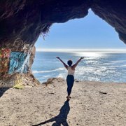
I relish the day that I can get a permit to backpack the entirety of the Enchantments, but on this occasion, Colchuck Lake was gonna have to tide me over. And did it ever.
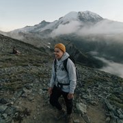
The hike in was strenuous, but I'd also just done Mailbox Peak, so it was easier in comparison (but not easy by any means). I had no trekking poles with me, which my knees kindly thank me for (not), but it wasn't nearly as bad as I thought it would be. The trail is mostly easy to follow and takes you straight to the camping area and an overlook of Colchuck Lake.
They don't even make an emoji to convey the look on my face. It was the equivalent of "f me sideways." I'd seen pictures of the Enchantments and always thought they looked magical, but this. Sylvester style tongue and jaw on ground. I was in actual awe. Between the turquoise clear blue waters of the lake, the mountain goat that doesn't seem to care you're even there, and the endless mountains covered in glaciers--like, what more could you want? You forget that your thighs are on fire as you look out over the lake. Walking around it for alternate vantage points was great too.
The way in took me 2.5 hours, 1.5 on the way out. Spent an hour walking around the lake, but probably could have spent the better portion of the day. Also! Of note! This trail is 4.8 miles each way, not 4 (WTA states this as an 8m RT). And that's just to the initial overlook/campsite. The hike around the lake is up and down, over boulders and tree roots as well, so that's definitely something to factor in!
There weren't many people on the trail and I started late (for me) at 8:30. By the time I was coming back down at noon, there were heaps of people (all very courteous and friendly), and the trailhead parking lot had filled in tremendously.
Once I got back to my car, I headed straight to Icicle Brewing for a half of the German Chocolate Cake Ale, the thought of which got me through the last 3 miles (the temps jumped from 55 to 80 while I was hiking. I was dressed for 55, not 80).
After Mailbox Peak, I said to myself, never again.
Would I do this trail again? Every opportunity possible.