Robert C.
Yelp
The Yosemite facebook announced the Mist trail opening on March 14, 2014 . Normally the upper part of the Mist trail is closed until May due to ice on the stairs.
We stayed at the Ahwahnee, and took the shuttle to Yosemite Village, and then a second shuttle to Happy Isles. It took about 1 hour even though it's less than 3 miles away.
Use the bathrooms at Happy Isles. The bathrooms at the bridge up the trail were still closed for the winter. Also fill up your water containers here, as the other bathrooms on the trail do not have drinkable water.
The first mile of the trail from Happy Isles to the bridge is paved and uphill -suitable for baby strollers, although I wouldn't call it wheelchair accessible, as the incline is pretty steep in places.
From one outlook on this part of the trail you can see Upper Yosemite falls in a distance.
This part of the trail is steep but it is wide with tall stone guardrails to prevent people from falling into the Merced rapids way below. Plenty of forest treetops to keep the sun off.
At about the 1 mile mark the trail dips, with a bridge running over the Merced river. You can see Vernal Falls in the background. The bathroom here was still closed for the winter.
Here the trail crosses the Merced river, with a very moderate uphill incline for about a quarter of a mile. The trail becomes a mixture of dirt and sand, running parallel to the river, under the trees.
The sign on the crossing gate states proceed at your own risk. The crossing gate is normally closed until May, but is open in 2014 on March 16.
There is a second sign, with a picture of a hiker being carried on a stretcher by a rescue crew of half a dozen paramedics and assistants. The sign warns hikers not to be one of the 200 people who are injured in falls on this trail each year.
Do not venture off the trail onto the rocks next to the river, from this point onwards, as the rocks are slippery, and people may slip and fall onto the boulders.
So far it has taken 1 hour to travel the 1.2 miles to this point. A sign says 0.3 miles to the top of Vernal Falls. It will take another hour to travel the last 0.3 miles.
The first set of stairs are small dirt stairs on a very broad trail, overlooking the rapids of the river.
Soon the stairs become stone stairs, and the trail narrows. People on the left side of the trail, however, are on the outside of the path, one misstep from sliding down the rocky slope into the river.
Normally this part of the trail next to the river is wet with mist from the roaring falls still a ways away. In 2014 there is no mist on the trails, as the water level is way below that of previous years. No need for a raincoat.
Eventually we reach a photographer's spot at the base of the falls, where one can take pictures of the falls plunging into the rapids.
The entire trail is in the shade at this time of year, so if you want to take pictures of friends in front of the falls, you will need a camera with a flash to see their faces -an ipad won't do.
Guardrails are on parts of the trail here, as the trail narrows to single formation, on wet stone steps from the nearby falls. You need hiking boots with good rubber soles on the bottom, to prevent slipping.
Once you get to the base of the falls, the trail veers to the right to the side of the falls. This is the steepest part of the trail, seeming going straight up, with stairs up to 18" high carved into the side of the mountain. I see kids climbing the rocks on all fours.
I'm huffing and puffing my way up, breathing hard like Darth Vader, using my hiking poles for leverage in getting up over the tall stone steps.
The trail eventually levels out on the side of a cliff, with guardrails on the side. It is so narrow, that only one person can move up at a time, with people in the opposite direction having to stop on sideouts.
At the top of the cliff, you can look down a ways to reach the top of the falls. There are guardrails preventing people from reaching out and touching the water at the top of the falls.
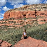
Classic photographer's spot here, with hikers posing in the sunshine against the guardrails, next to the falling water.
This is the spot where you have people going over the guardrail to touch the water, or get a more daring picture of them next to the waterfalls. One wrong step and over the edge you go to heaven.
We sit on the rocks and eat lunch here. There are restrooms about 200 yards upstream, near the small lake above the falls.
Coming down the trail takes less exertion than going up. I go sideways, maximizes the footprint on the stairs, and minimizes the chances of slipping.
In the summer and on weekends, there will be crowds of hikers, all jostling to go up the trail, and passing the slower hikers.
It takes me 2 hours to go up and 1.5 hours to go down. At this time of the year, there was no need for rain gear, and no need for a hat, as the trail was in the shade until the very end.