Robert C.
Yelp
Tired of all those folks boasting about their Angel landing hike? Well do the Observation Point hike, and you can look down on them, and thumb your nose at them at the same time. Literally.
I start out at 4200 feet elevation on the Zion Canyon floor at 10am on a cool April morning. Like a lot of hikes from the floor of the Canyon, this hike has little cover, lots of switchbacks, and is going up under strenuous conditions, and then hiking back down.
The first three quarters of a mile is all work, going seemingly straight up the cliff on the long innumerable switchbacks, over broken concrete and rocks. You reach a fork in the trail, at 4700 feet elevation, with the right going to Hidden Canyon, and the left fork going to Observation Point. 500 elevation gain in about 3/4 mile!
The Observation Point trail continues up on long traverses up the side of the mountain, dirt trails, no cover except that it is in the shade in the morning. You do not want to do this hike in the summer, otherwise you risk becoming a permanent resident - a deceased resident!
Bring a hat and plenty of liquids -I only needed two 20 ounce bottles of water, but then it was cool, with highs in the low 70s.
Hiking poles would help on this hike -can't use the hiking poles on the Angel landing hike, if you are going to be pulling yourself up with the chain cables on the mountain side.
At the top after the first series of switchbacks, one enters Echo canyon, with a straight path alongside a river gorge, although this gorge is for the most part dried up. There is one place where there is water, deep inside the narrow canyon, where Zion adventures suited people try out their wet equipment.
We reach 5600 feet elevation, a 1300 foot elevation gain, before we encounter another set of switchbacks. Yellow colored Navajo sandstone, and then orange colored sandstone on the walls of the mountain sides of the dirt trails. Sparse forests, with tall cliffs surrounding in the distance.
It is here, that one encounters narrow trails, with long steep drop-offs. The trick is to never go too close to the edge, and never look down.
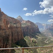
One reaches a plateau, where one can actually see Observation Point a mile away, a white cliff, stained red with water streaks running down the cliff. First dirt, and finally sand, as one approaches the end of the hike at 6507 feet elevation, after 3.5 hours of hiking. The last 100-200 yards is all red clay, with forests of green trees.
Dozens of people here, with grandiose views of Zion Canyon, with the Virgin river meandering through the canyon, and of Angel Landing some 700 feet below, and off in a distance. You can see the entire half mile of the ridge to that trail, but can't make out the people holding for their dear lives onto the chain cables in that hike.
Permanent residents these squirrels running around, but don't let them climb onto you -their claws will rip your clothes and skin to shreds.
Coming down is easier than going up, but hard on the knee joints. Even at 3pm I was seeing people in the first half of the hike coming up. Don't want to stick around here when the daylight retreats around 7pm -imagine going down the trail alongside the long drop-offs in the darkness! Better hope for a full moon!
I reach the trailhead and the free shuttle at 430pm, after 6 hours of hiking, 8 miles, 2148 feet of elevation gain. My knee joints are in pain going the last steps downhill, but kept at it, with the encouragement of people 40 years younger!
.