Rebecca T.
Yelp
I will not forget this day. It was the most emotionally and physically intense day of my life so far. If you're thinking about doing this, let me tell you it's totally worth it, regardless of the long, exhausting hike. By far this is the most amazing, rewarding, challenging and breathtaking trek I've made. We have traveled quite a bit, have seen a lot of amazing natural wonders, but Trolltunga is definitely the one that left us speechless and in awe, even now almost a week after we did it. There is no easy way to get here, no tram, no bus, no gondola, no magic carpet. It's either by hiking 10 hours round trip (on average) or by doing what we did.
We did the bike + hike + climb via ferrata Himmelstigen with our tour guide named Theo with Trolltunga Active. Our trip started at around 9:30am by first biking along a section of the lake before we started hiking and climbing. Biking on gravel wasn't easy and we had to pass a couple of waterfalls, so make sure you hold on to the steering wheel tight and be prepared to get your boots wet because certain parts of the trail were flooded with gravel blocks that were too big to bike over. Also, when we signed up for it, we thought biking along the lake would be flat and easy... No! The trail was like a rolling hill, gentle up and down slopes. Walking on a slight incline is fine, biking on an incline is 10 times harder. But finally, we got to the beginning of our hiking trail after biking for an hour. From then on it was all going straight up. Well, we're heading to the top, so there's only one way, up up up!
The lower part of the trail was a lot of soil, brushes and trees. It was easy to hike up but more challenging to hike down in the rain because the branches were super slippery. As we got higher, we found ourselves in a wash that had active and dry river beds full of big and small boulders. This part was definitely testing our ninja skills, bouncing from boulder to boulder. It was fine on a dry day, but it was no fun when it's raining. The brown and green algae were as slick as a troll's tongue. All of us except for the guide, who's basically a mountain ninja, slipped and fell at least once. Here, I have bruises and cuts to prove it. As we got higher, the boulders got bigger and bigger. Some of them were so big that we were hoping no rock would come down on us like that.
Finally we reached the beginning of the climb after about 2 hours of hiking. Seriously we were already tired from the biking and the hiking, but we still had to climb! Theo showed us how to put our harness on and made sure it was secure. When we were up there, it is this strappy thing that presses against your balls that will save your life, well, somewhat. The via ferrata is something similar to the Half Dome in Yosemite, if you're familiar with that. I haven't been to the Half Dome, but that was what our tour guide was saying. There were iron handle bars drilled into the cliff face and you climb it like a ladder - some parts are vertical, some slope inward, some overhangs. There are ropes and steel wires next to the ladder steps onto which you secure your carabiners in case of falling. As our legs were already exhausted from the biking and the hiking, we were really pushing our quad muscles to work even harder for the climb. We were too tired and focused to even worry about heights.
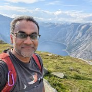
An hour later, we're finally at the top! The view was surreal. The rocks were all black and layered (foliated in geologic term) with most areas covered in pure white snow. Previous hikers have carved out a hiking path for us in the snow, but it was still slippery but fun. We wanted to spend time enjoying the snowy mountain view, but were too anxious to see what Trolltunga was like! We walked on snow, over one big black boulder, another boulder, and another boulder, and finally we reached the very top of the last boulder. The view opened up with the faraway snow-capped mountains that were as high as where we were standing, and of course, the Troll's tongue, a wedge of dark rock jutting out over the deep blue lake that we biked along. I started crying. Finally, after all the exhaustion, pain, blood and sweat, we are here! The view was breathtaking, serene and surreal. The snow made the mountains even more majestic than they were already. The deep blue lake brought out the peace in me, but the moment I looked at the Troll's tongue, I started feeling anxious, because it reminded me how high we were! After all, an Australian girl did fall to her death a year or two ago from Trolltunga.
The way down was actually more brutal because I had no anticipation and motivation to muster up my last bit of energy to climb, hike and bike AGAIN. What would that be? food? sleep? home? It started to rain on us on our way back making the trail slippery and harder to walk on, but eventually we made it back after 13 hours of exhaustion filled with adventure, wonder and courage.
Yes, I would hike this tongue again.