Waterrock Knob

Mountain peak · Jackson County

Waterrock Knob

Mountain peak · Jackson County

1

North Carolina 28779

Photos

Waterrock Knob by null

Highlights

Stunning mountain views, picnic spot, visitor center & hiking  

Placeholder
Placeholder

North Carolina 28779 Get directions

nps.gov

Information

Static Map

North Carolina 28779 Get directions

+1 828 298 0398
nps.gov

Features

Last updated

Oct 24, 2025

Powered By

You might also like

Terms of Use • Privacy Policy • Cookie Policy
 © 2025 Postcard Technologies, Inc.
@travelleisure

Western North Carolina Fall Road Trip

"A convenient, moderate summit stop along the scenic corridor that provides panoramic fall views and makes a worthwhile addition to drives on the nearby scenic roads." - Lydia Mansel Lydia Mansel Lydia Mansel is a writer with more than eight years of experience editing and writing for both brands and online publications—with a particular focus on travel, fashion, and lifestyle. She’s also the founder of the travel site justpacked.com.  Travel + Leisure Editorial Guidelines

https://www.travelandleisure.com/western-north-carolina-fall-road-trip-8717875
View Postcard for Waterrock Knob

Danette Kuzel

Google
We thoroughly enjoy driving up to Waterrock Knob. Such beautiful views in all sorts weather. Many times clouds change the gorgeous views you experience & remind you of why it's called the Smoky Mountains. Many times we drive up with a picnic lunch, chairs and a book. So quiet & serene

Emily Sala

Google
My husband and I did this hike with our dogs and it was beautiful at the top but the trail is pretty steep. From the parking lot to the lookout is paved but beyond that it is very rocky and a pretty rough and steep trail.

DeeRo Holla

Google
Just shy of a 2 Hour Dr. from Greenville, South Carolina, chasing a sunset that is rarely seen in the Greenville area, we rolled the dice and headed out, hoping that it would pay off. It did not disappoint . The drive up to the Outlook is beautiful with numerous overlooks along the way. We went on a Sunday and avoided a lot of congestion probably because it’s not as popular of a day to travel as Saturday. There was still a full parking lot, but we got there early and got to choose a place in the Grass that was perfect There is not any food or beverages once you get on the parkway up to Water rock so make sure you pack what you need. Restroom facilities were clean and stocked! And added perk for us was the temperatures in the humidity were significantly lower than the Piedmont 74° with a mountain breeze and virtually no bugs We plan on going back this coming weekend because once it’s just not enough! This time we plan on making the half a mile hike to the top.

Susan Wilke

Google
This was a fun hike. The first part is a fairly steep paved path. After the stairs and a "patio" area it is a more natural rock path. I enjoyed the natural path part most. I loved hearing the bees, seeing the lovely trees & rocks, and the "adventure" of climbing the rocky path. There are many paths carved by folks off of the main path as well. It also seems to meet up with the "Mountains to Sea" path. (Not sure if I have that trail name correct. 🤔) Once you are at the top, there is an area just to the right and down a bit with a big rock to sit on and enjoy the view. It is spectacular even with all the clouds.

Jacob Parris

Google
Family friendly and easily accessible within a 30-minute drive from Downtown Waynesville. Come for the views, the picnic tables, or the scenic trails and overlooks a brief walk from the parking lot.

Gintar “GS” Senfeld

Google
Very nice view , there is very little and easy Trail to hike 0.5 mile .

Svetlana Babicheva

Google
Gorgeous views for sunset and sunrise, easy access to trail.

Brian Rose

Google
This is a beautiful spot to take in a sunset. There are beautiful views of The Blue Ridge Mountains in all directions. There is ample parking at roughly 6028 feet elevation with beautiful views and if you are feeling good There is a ½ mile walk to a higher spot. Be sure and take a jacket in spring or fall as it can get quite chilly at altitude in the wind.
google avatar

Kathy V.

Yelp
A super challenging (very very steep) short hike up a tall knob. A longer hike if, like me, you started at the trailhead at the Fork Ridge Overlook farther up the parkway. The views are spectacular, the hike is challenging (even for fit and athletic folks). Take your time, but the climb is worth it. And I definitely recommend the longer trail if you are up for the hike!
google avatar

Brittany M.

Yelp
The initial climb is NOT for the faint of heart. We've hiked this easily over 30 times and every time we see people quitting on the initial paved, very steep entry around the 50ft mark. Please be respectful if you divert to the plane crash. The top view is breathtaking, along with several viewing spots along the way. Pet friendly, but make sure they are hiking capable as there are quite a few steep steps and sharp curves.
google avatar

Theresa C.

Yelp
This is a 5 star stop if you don't go when it's raining and fogged in. Unfortunately that's when our tour went through. There is a small visitor center with pit toilets. Even though we couldn't see the spectacular view, it was cool to watch the fog swirling around and down the mountain.
google avatar

Mike G.

Yelp
This is well worth a stop in the Blue Ridge Parkway. There is a massive parking lot with a gift shop, bathrooms and picnic tables. The hike to the overlook starts with a steep incline and then a steady walk up to the overlook. I was disappointed because it was so cloudy when we reach the top that we couldn't see 20 yards in front of us. The main reason we stopped was to walk to the plane crash site, about 2.5 miles off the main trail. This is not a maintained path but there are plenty of forums online about how to reach the plane. Take caution, this is not the easiest walk and does take concentration as the path is unsteady, rocky and slippery when it rains.
google avatar

Charlene C.

Yelp
Arrived here at 7am on Saturday, 6/20/20. There were barely any people, which was nice. Didn't realize this is also an overlook so you can still enjoy the beautiful view without going on the trail. The sun had not yet risen above the mountains so there were still pretty light orange and pink colors on the mountains. It was a little windy so it was kind of cold in the parking lot area. Once I started on the hike, I worked up a sweat quickly. The parking lot is spacious and the unisex bathroom I used was clean (might not be so much later on in the day). The bathroom I used also had a wall hand sanitizer dispenser. The beginning of the trail is paved but becomes more rocky with a few steps. The trail was well-maintained. It was a little tricky going down because some of the rocks were wet and slippery. It might be a good idea to have trekking poles if you need more support. The trail is also narrow so you might want to bring a mask if there are a lot of people. The elevation is 456 feet, taking 0.5 miles to get the very tip of the top with an overall round trip about 1.2 miles. So it is a quick moderate steep climb. There is an overlook with seating at 0.2 miles into the trail, but you get better views at the ground overlook and further along the trail. I had clear views of the mountains along the trail and at the top. I took my time taking a lot of pictures so I spent 1hr 15 minutes to complete the trail. If you're not looking to take a lot of pictures, then I would estimate it taking 30-40 minutes, depending on your pace. Don't forget to catch pretty views going back down the trail. The trail is worth doing!
google avatar

Ward D.

Yelp
A very nice visitor's center that has a nice trail to a viewing area above the center. The Blue Ridge Parkway is about 470 miles long and connects the Shenandoah National Park in Virginia and the Great Smoky Mountains National Park in North Carolina. The parkway boasts about 170 official stops along the path. This site is one of these many stops. There are several sites at this location. There is a path up to a viewpoint at a higher elevation, a visitors center, a building with restrooms, and open areas with stone tables and benches. The visitor's center is located at the end of a needle-shaped parking lot with a lot of spaces (about 75 or more). It is a single building with large plate glass windows providing you with a view across the northwest side of the mountains. The ceiling is light-colored wood and the walls are stone. There are several displays explaining the animals in the park and the park itself. It is a nice visitor's center with a small gift shop, an informational presentation in the middle of the room, friendly staff, and a great view. Overall, it is a good stop for a visitor to the park and this location.
google avatar

Tracie P.

Yelp
Water rock knob is a high altitude stopoff in the Blue Ridge Mountains. The site features picnic tables at the parking lot overlook and is a stunning spot to grab lunch or watch a sunrise/sunset. There's a short trail (1.2 miles) round trip to the summit. It's incredibly steep, but the views are well worth it! There's a point in the water rock knob trail where you can drop off and trek to the site of a plane crash (the Cessna is apparently still mostly intact, although the engines were excised to support the investigation of the crash). We didn't do the trail to the site, but saw several people who were headed there. Because of the altitude, it may be a bit cooler here (so you'll want to bring a long sleeved shirt, even during summer).
google avatar

Michael B.

Yelp
The hike from the visitors center to the peak is just under a 500 ft elevation rise in approximately a half mile hike. The views are great but the hike is difficult with small kids or if you have physical ailments. I believe the hike to the peak may be the 2nd highest point along the parkway, so if you have time and physically can manage the hike, do it, you won't be disappointed.
google avatar

Joy X.

Yelp
It's a .6 mile hike to the summit and a roundtrip of 1.2 miles total. My parents are in their early 70's, so they brought their walking sticks (I'm not sure the brand, but same ones my dad used for Santiago De Compostela [We're a very outdoorsy family] where he ended up walking over 100 miles) to help them hoist up for stability for relatively steep rocks and tree roots. Since I'm short, I def. hung onto the rails (very helpful). I love hiking and def. got a good workout for my glutes, calves and core. The hard climb is going up the trail, but going down is far easier. :-) There's a mix of young kids and much older retired people doing a better job hiking compared to myself, but my lungs kept me going and just love strolling up the mountainside; I bet the views are extraordinary during different seasons when foliage change, especially fall. It was so neat hearing the bees around you pollinating yellow and white flowers and made me feel like I was inside a beehive. It was hot even with the sun poking through the clouds & radiating on my dark hair, made me wish I had a straw bamboo, Southeast Asian rice patty hat, so my brain didn't fry (bring a hat)! I loved the fresh, pure, cool mountain air and shadows on the mountains (very scenic) and beautiful wildflowers.
google avatar

Tim M.

Yelp
Stunningly beautiful with panoramic views of the Blue Ridge Mountains. Ample parking, restrooms (no water) and well kept grounds. The hike from the parking area to the actual overlook about 15 minutes (all up hill, but good trail). There are other trails including MTS and the yellow blaze trail to Browning Knob. That trail is underrated as a moderate hike. It should be rated difficult, especially when muddy. It is about a 1.5 miles of challenging slippery and muddy trails, but it leads to the site of the 1987 Cessna plane crash.
google avatar

Rachael P.

Yelp
Beautiful spot to watch the sunset! Unfortunately, my cousin and I went there when it was foggy, but we still hiked a little ways up to an overlook and enjoyed the view from the parking lot
google avatar

Arlis A.

Yelp
What a great little hike. It's a steep climb but it isn't very long. Once at the top it was nice to take it all in and relax. You can see for miles up there. The visitors center has parking, bathrooms, picnic tables, and a gift shop. Nice to bring lunch and eat on top of the world.
google avatar

Amy S.

Yelp
Waterrock Knob is part of the Plott Balsalms range. Located at Milepost 451.2, it is the sixteenth highest mountain in the East. It has a visitors center, bathrooms, and a 1.2 mile roundtrip hike to the top. It gets tough, as this hike gains 412 feet in elevation from the parking lot. I assumed that the grand finale would be two minutes away. It was more like twenty-five. I lost 1.2 pounds getting to the top. Seriously, keep this in mind. I was breathless at some points due to extra padding and the nerve of some higher beings. The whole area is a great place to catch spectacular sunrises and sunsets. Even in the parking lot! We left before sunset proper, and it still was breathtaking. On a clear day, you have views up to fifty miles away. Below, you have the town of Maggie Valley. If you are a viewphile, the view is not 360 degrees. Hey, some people are picky. Let me tell you more about the hike up. It is paved for a bit until you get to some steps that lead you to a flagstone patio. It is a sweet resting point. You can sit on a rock wall and dream, or stonewall. My kids ran away, so I followed them up. "Up" turns to a dirt path with stones. Some areas have been designed by nature; some by rangers to make foot travel easier (e.g. flat rocks placed in certain ways, even as steps.). Some areas are gradual, some are steeper. One point had me dizzy with fear, because my daughter Ronni makes it a race with me always at her far back. Anyway, the way up is beautiful, bountiful, and bouncy. I do not want to say too much, because I believe in surprises. 
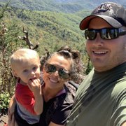
Getting to the top is worth all that above stuff. Sometimes one is quieted. Some people get boisterous. I stay away from the edges, as I am not sure if they will give or if my curiosity of flight will not. My children were free spirits at the top. They enjoyed it, and knew instinctively to stay away from the edges. It is intense for certain types. Keep toddlers and saints away. I can still feel this place, and I like that. It can be a simple visit if you want it to be so, or lofty if you feel up to it. Both ways are grand. Opens seasonally April 29th. Hours are from 10 a.m. to 5 p.m. Calling up will get you a recorded message with select info, even a foliage report. Here is another phone number: (828) 348-3400; just in case. Website has very helpful area alerts.
google avatar

Shannon L.

Yelp
The hike was much like others stated, not easy but well worth it. My husband and I took our 2 year old up and helped him along when he didn't want to try the steps himself. Could the trail use some maintenance, yes, but you then remember your on a hiking trail up a mountain. You know your going to get some hard spots to traverse. All of us were very tired but the view was beautiful. I will say that the one star deduction is because people do not clean up after their pets on the trail and the smell was so strong on a not hot day that sometimes you just had to hold your breath. Please make sure that you are not one of those people that are leaving poop on the trail. Will go again one day to see a sunrise or set depending on the time of year.
google avatar

Alison W.

Yelp
Incredible. Photos will never do God's creation justice. Moderate skill level. 8&10 year old did it too. It's over 400 feet elevation hike from visitors center to get to over 6,000 feet in elevation. You'll need good walking shoes to make it all the way to the top. Visitors center closes at 5:00. Great gift shop and you can stamp your national park passport book. Great family memories today!!
google avatar

David B.

Yelp
This is at about the 5800 foot elevation with amazing sunrise and sunset views. If you look carefully you can see the casino to the west. Bring a jacket because the temp is about 10 degrees cooler than in Maggie Valley but feels 20 degrees cooler ( March 2021 ). It's a steep hike from the parking lot up the trail. An additional hike off the trail will take you to a plane wreck.

Oenita B.

Yelp
Waterrock Knob is a lovely place for everyone. Picnic tables, restrooms, hiking trails, and unbelievable views are easily accessible from the parking area. However, the trails are not for those with walking difficulties. One can appreciate the view from either side of the parking area without even getting out of your vehicle. You can see for many miles east or west.
google avatar

Linda L.

Yelp
Of all the places on the BRP one of the only you can experience a sunset and a moonrise. Great picnic facilities we have tasked advantage of and even rustic but private restrooms

Rebecca M.

Yelp
One of our favorite places for amazing views. The sunsets and rising of the moon are beyond stunning. We have been visiting here for 20 plus years on vacation and now we live here and go whenever we want. Plenty of picnic tables and bathrooms really make this spot perfect.
google avatar

Albert C.

Yelp
This hike is a great stop along the BRP. It is 1.2 miles total and a 472 foot climb to the top and pretty steep. The first half is paved with a place to rest. The remainder is dirt and rock with some steps. The trail is pet friendly. The views from the parking lot and top are unbelievable. The welcome center has drinks, snacks and restrooms.
google avatar

Mary F.

Yelp
Awesome views! The best sunsets. A must for any visit to the Smokies. Don't miss this seemly endless view of the smokies.
google avatar

Caroline Z.

Yelp
This had almost everything you could want in a hike! The visitor center was basic, but appreciated. What's really great about it is the surrounding views, you don't even have to hike to get some amazing pictures and enjoy the fresh mountain air. The path to the top of the mountain is half a mile, but feels longer since it's a steep incline. It's partially paved, but even where it isn't there is a clear path and stone steps throughout. (Side note: it is much more challenging than an actual paved walking path, so beware if that's what you're hoping for.) If you just want to get to the top and back down it's a 1 mile round trip, however there are less traveled paths you can veer off of from the main path, which is nice if you're looking for a longer trek. The views are partially blocked during the summer months or on particularly cloudy days, so plan accordingly.
google avatar

M S D.

Yelp
This is the perfect spot to watch the sunset! It's right off the BRP between Maggie Valley and Cherokee!
google avatar

Jim P.

Yelp
This mountain was an unpleasant experience. My friends and I wanted to go up the mountain to simply have a fun time and walk around and experience the views, but this treacherous half mile hike was the death of us. Mind you, we're all athletic and run a mile a day and play multiple sports so we thought it would be an easy half mile with a small incline. We had twenty minutes to get up there and by the time we got there it was already past sunrise which is what we came to see. Not only is the description misleading as to what you'll be experiencing, it also was really excessive and really not worth the hike. The view was pretty which Is the only reason it's worth two stars for this treacherous and unruly hike. Another point that made it not worth the hike was the trail itself. It was unkept and very difficult to get up and down. I slipped multiple times trying to get up and down the mountain and I know my friends had trouble too. All-together it was a horrible experience and I normally don't review anything but this was such a terrible experience I don't want anyone else going through this like my friends and I did. The other five stars are either from people who didn't have places to go afterwards and was late or bots because it was truly an unruly experience that I hope no one has to go on. I don't listen to reviews normally but this one is real and personal and important. Please find a better place to go that's kept up and safe.