Charles Mound

Mountain peak · Scales Mound

Charles Mound

Mountain peak · Scales Mound

1

Scales Mound Township, IL 61075

Photos

Charles Mound by null
Charles Mound by thomasharper (Atlas Obscura User)
Charles Mound by null

Highlights

Placeholder
Placeholder
Placeholder

Scales Mound Township, IL 61075 Get directions

Information

Static Map

Scales Mound Township, IL 61075 Get directions

Features

Last updated

Mar 5, 2025

Powered By

You might also like

Terms of Use • Privacy Policy • Cookie Policy
 © 2025 Postcard Technologies, Inc.
@atlasobscura

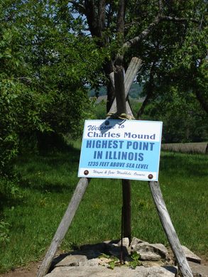
"While the highest natural points of many US states are in parks or other protected areas, the highest point in Illinois is at the top of a family’s driveway. At 1,235 feet above sea level, Charles Mound is the highest elevation one can reach in the state of Illinois. The northwest corner of the state is in a unique geological region called the “Driftless Area,” in which the land was not covered by glaciers during the last Ice Age. The resulting area is a uniquely eroded plateau cut with deep river valleys. The owners of Charles Mound, Wayne and Jean Wuebbels, graciously allow access to interested visitors on the first full weekends of the summer months and Labor Day weekend, only (not including Labor Day itself). All other requests will be denied. These dates are posted at the Highpointers’ Club website. The Wuebbels ask that visitors follow these three rules while on their property: 1. Come during daylight hours on the specified dates; 2. No parking up the driveway - please leave vehicles near the gate and walk the 1.2 miles on the driveway to the marker area, and please do not crowd the road as farm equipment may need to pass; and 3. They can’t accommodate pets. At the summit, the Wuebbels have a marker for the benchmark and chairs so visitors can take in the views of Illinois farm country. They have welcomed guests from all over the world at the top of their humble, if long, driveway." - ATLAS_OBSCURA

The Highest Places in America
View Postcard for Charles Mound

Mark Wyssbrod

Google
A beautiful arra, easy hike, but it is o private land...so check the availability to access the property

Robby Chiramel

Google
Nice view and 1.5 miles walk to reach the point

John Nelson

Google
A easy 1.3 mile hike from the road to get to the highest point in Illinois. Scenic and some good breezes along the way. There are 2 Geological Survey markers “up top” and 2 chairs that you can sit on to rest if you want as well as a sign in book. The walk there was all uphill and the walk back is all downhill. Can get a little buggy by the ponds. Only open certain weekends of the year so be sure to search for schedule and don’t trespass as it’s private property. We went July 2nd. Also there is a large “Jesus Saves” sign along the road that I took a photo of that looked interesting (I’ve seen it on the diorama in Galena but didn’t realize it was real.

Wanderfish

Google
Charles Mound is located on private property, and therefore public access is limited. It is currently open to visitors only during the first weekend of June, July, August and September. They've also added one winter access day in February but note that the access lane is not plowed. Please do your research before visiting and stick to the well-defined and outlined rules you can easily find with a bit of googling. Since this is private property, the owners can decide to close this off to the public at any time. We were there on July 1st, and we were outnumbered 3 to 1 by rule breakers. There were over 30 names on the logbook for the day by the time we arrived. If you are a fellow high-pointer, explorer, geocacher, Waymarker, Benchmarker or history buff - how can you NOT love a high point?

Jerrod Border

Google
Wanted to thank the owners for making this available to the public. We loved the black cat that greeted us at the top.

William Taylor

Google
It is so wonderful that the owners allow people to come here a few times a year. PLEASE respect private property and do not hike this unless it is specifically open. It is currently open to visitors only during the first weekend of June, July, August, and September. They've also added one winter access day in February but note that the access lane is not plowed. It was peaceful, we got there at 7am, 1 hour after it opened in August, and we were the only ones. Definitely hit it up, the views are incredible too.

Alex de la Torre

Google
A very unique high point indeed. This is the least accessible of all high points, as it is on private property and only open ten days out of the year. If you want to visit, you will need to go in the first weekend of June, July, August, or September, or President's Day Weekend. If you do make it, it is an easy one-mile stroll down a gravel driveway, with a small vertical gain. And---there are actually some views here (into Wisconsin of more farmland, but still pretty). Three markers (one is hidden in the bush across the driveway), a welcome sign, some chairs, and a register up top as well. A very nice place. The Wuebbels family has been very generous in allowing us to visit at all though, and I am hoping that some form of access will be preserved for the indefinite future, but that could be in jeopardy if the place ends up being sold to the wrong person...

Natha B

Google
It is private drive way open not always. When you get there and see gate open, you may hike to hike point 1.1 mile oneway. Nothing there only waymark. Walk us beautiful, on top is partially trees covered view. It was tower there 20-30 years ago and now private house.