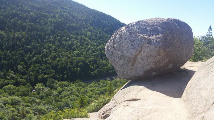
"In the middle of Acadia National Park in Mount Desert, Maine, you’ll find Bubble Rock. Named for the precariously balanced titular structure, it was created tens of thousands of years ago by glacial erosion, which slowly created the formation that perches on the edge of a cliff overlooking the South Bubble summit. Geologists have estimated that the rock originated 40 miles to the north near Lucerne. The course-grain on its surface is indicative of its white granite composition, which differs from the surrounding rock of Mount Desert Island, typically a pink granite hue. The trail to reach the rock is moderate, about 0.7 miles one-way, and can crossed through the Bubbles Divide Trail or Bubbles Trail. Parking is available for all hikers further down on Park Loop Road, about a mile south of Bubble Pond and 1.5 miles north of Jordan Pond House. Bubbles Divide Trail heads west from the start, crossing the Jordan Pond Carry Trail and upwards into a wider, more graded trail. The Bubbles Trail joins from North Bubble from the right, eventually merging. The trail includes two notable forks, which lead to North Bubble and South Bubble, the former being the higher summit at 872’/266 m and the latter at 768’/238 m. While Bubbles Divide Trail descends straight forward, a left turn bears into Bubbles Trail. Another boulder - not Bubble Rock - can be accessed through a short trail on the right, with a ledge overlooking the ridgeline of Sargent Mountain. Further up ahead is an opening from the tree cover into the summit. Finally, a short trail to the left leads downhill to the edge of the cliff and Bubble Rock. South Bubble provides a view of Jordan Pond, Pemetic Mountain, Penobscot Mountain, as well as the ocean off of Seal Harbor. Another trail further down also leads down to the Jordan Pond, although the trail is notably more precarious and steep, despite its moderate trail rating." - ATLAS_OBSCURA