
1
Jawbone Flats

A Nature Lover's Guide to Oregon
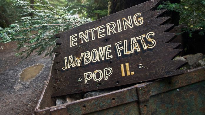
"In the year 1859, miners came to Opal Creek Forest and struck gold. By 1931, what used to be land used by the Santiam Kalapuya Indians for vision quests and trade routes became a bustling mining camp by the name of Jawbone Flats. After a successful run of producing lead, zinc, copper and silver, the mining company ceased activity in 1992, but not before a group of environmentalists calling themselves “The Friends of Opal Creek” focused their attentions on the land that the mines inhabited. Formed in 1989 and dedicated to preserving the 35,000-acre Opal Creek watershed, the group was rewarded for their commitment to the area when the Shiny Rock Mining Co. gifted to them 151 acres of land – Jawbone Flats and a stand of old-growth forest worth $12.6 million. The Friends of Opal Creek have since taken up residence in the abandoned camp, and turned it into an educational center, focusing on teaching visitors about Opal Creek’s uncorrupted ecology, including its temperate rain forest conditions and 800-1,000 year old Douglas firs and Western red cedars. The camp itself is still pretty much right where the Shiny Rock Mining Co. left it. The accoutrements of the camp, early 20th and late 19th century Cascade mining and logging equipment, old cars and hauling trucks, and a scraggly band of rough-hewn cabins, lay scattered around the property unattended. Rusted and forgotten, the forest so carefully protected has begun to overcome the equipment of industry, and is slowly devouring it. Classified as the largest repository of Cascadia mining equipment in the world by the USFC, the dinosaurs of the mining industry now serve as a rustic backdrop for the ancient trees they lie amongst. Now renamed Opal Creek Ancient Forest Center, the buildings in the abandoned town are being restored, and the cabins can be rented. It’s a favorite spot for hiking enthusiasts due to its incredibly scenic views as one of the last uncut old-growth forests of the Pacific Northwest, with the occasional dilapidated 1950’s pickup thrown in the mix. Update as of November 2021: Access to this location is currently limited due to a fire." - ATLAS_OBSCURA
Information
Self-sustaining ghost town with mining relics and old-growth forest


National Forest Development Road 2209 (Trail), Gates, OR 97346 Get directions


")
")
")

")
")


